
Tomas Pueyo is the author of Uncharted Territories, a newsletter helping readers understand deeply how the world works today to navigate the world of tomorrow. You can subscribe to it here.
Do you like the Mediterranean? Should we make more seas like it?
Today, the Mediterranean region is one of the best places in the world to live, with an amazing climate, developed economies, and some of the best beaches on Earth — but it wasn’t always like this.
Roughly six million years ago, shifting tectonic plates closed the Strait of Gibraltar — a narrow body of water connecting the Mediterranean Sea to the Atlantic Ocean — turning the area into a desertic wasteland. About 700,000 years later, the strait burst open again, and a brutal megaflood filled the Mediterranean in a matter of months.
Without that event, we wouldn’t have a Mediterranean Sea — and potentially no Roman Empire, no early European development, no Age of Discovery, no Industrial Revolution, and no United States. The world would be dramatically different.
We don’t need to be satisfied with just one Mediterranean — we have the technology to create more seas like it. So, do we want to create more? And if so, where?
Hunting depressions
The Mediterranean Sea filled with so much water so quickly because its floor is below sea level, which allowed ocean water to rush in once the Strait of Gibraltar reopened. So the first step to figuring out where we could create more seas is to think about where else in the world we have similar depressions.
The Caspian Sea
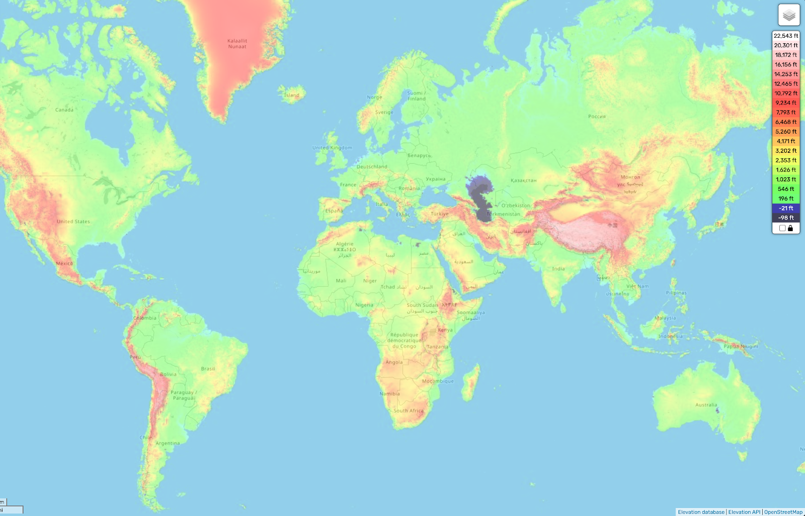
Did you know that the Caspian Sea is this big? A significant chunk of its northern coast is below sea level, too, and could be filled — but the area is highly populated today, so that’s probably a bad idea.1
Not too far away, however, there’s a much more promising spot.
The Dead Sea
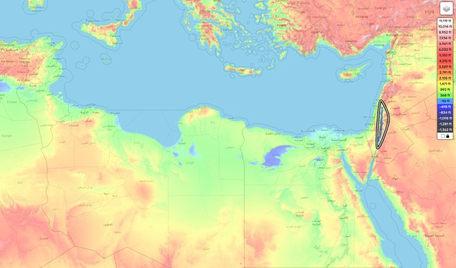
At its deepest, the Dead Sea — located between Israel, Jordan, and the West Bank — is 2,400 feet (730 meters) below sea level. Its surface, meanwhile, is 1,400 feet (440 meters) below sea level as of 2025, but its water levels are falling fast.
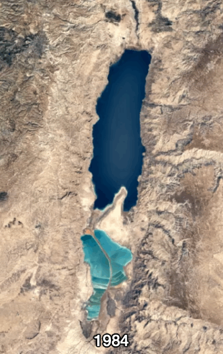
The Dead Sea’s salinity is 34%, nearly 10 times higher than the Mediterranean Sea’s 3.8%. If we created a pipeline from the Mediterranean Sea to the Dead Sea, it would not only add much more water but also make it much less salty. This would allow algae, fish, and birds to return to the sea, perhaps inspiring a name change: the Alive Sea.
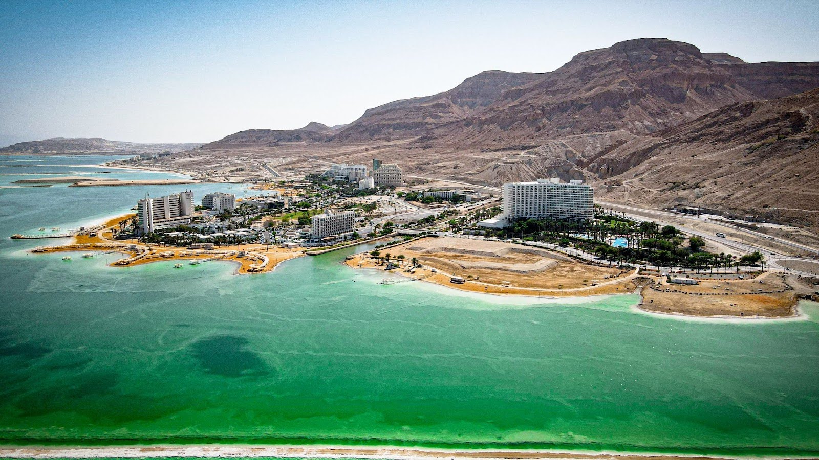
The Dead Sea is already home to some resorts, and increasing the amount of water in it while reducing its salinity might also increase tourism in the area.
At the same time, we could use the water flowing from the Mediterranean to generate hydroelectricity. This could be used to desalinate some of the saltwater and turn the southern Negev Desert into lush agricultural land.
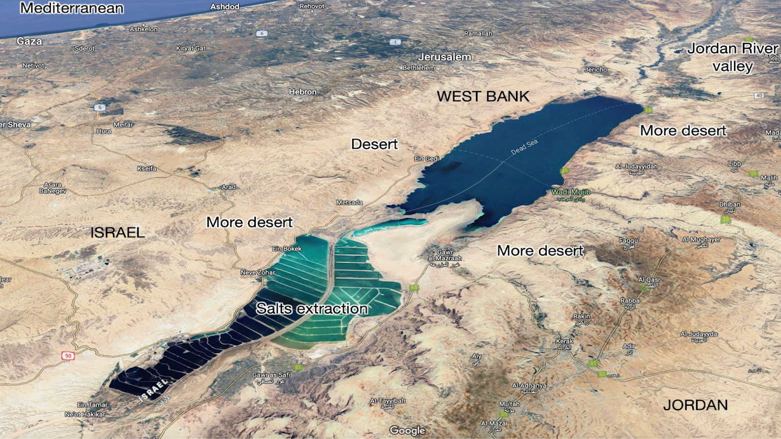
That was the goal of the $10 billion Red Sea–Dead Sea Conveyance (RSDSC), a planned pipeline from the Red Sea to the Dead Sea. Jordan abandoned the project in 2021, though, because it would have required a lot of cooperation with Israel, and Israel’s support was not forthcoming.
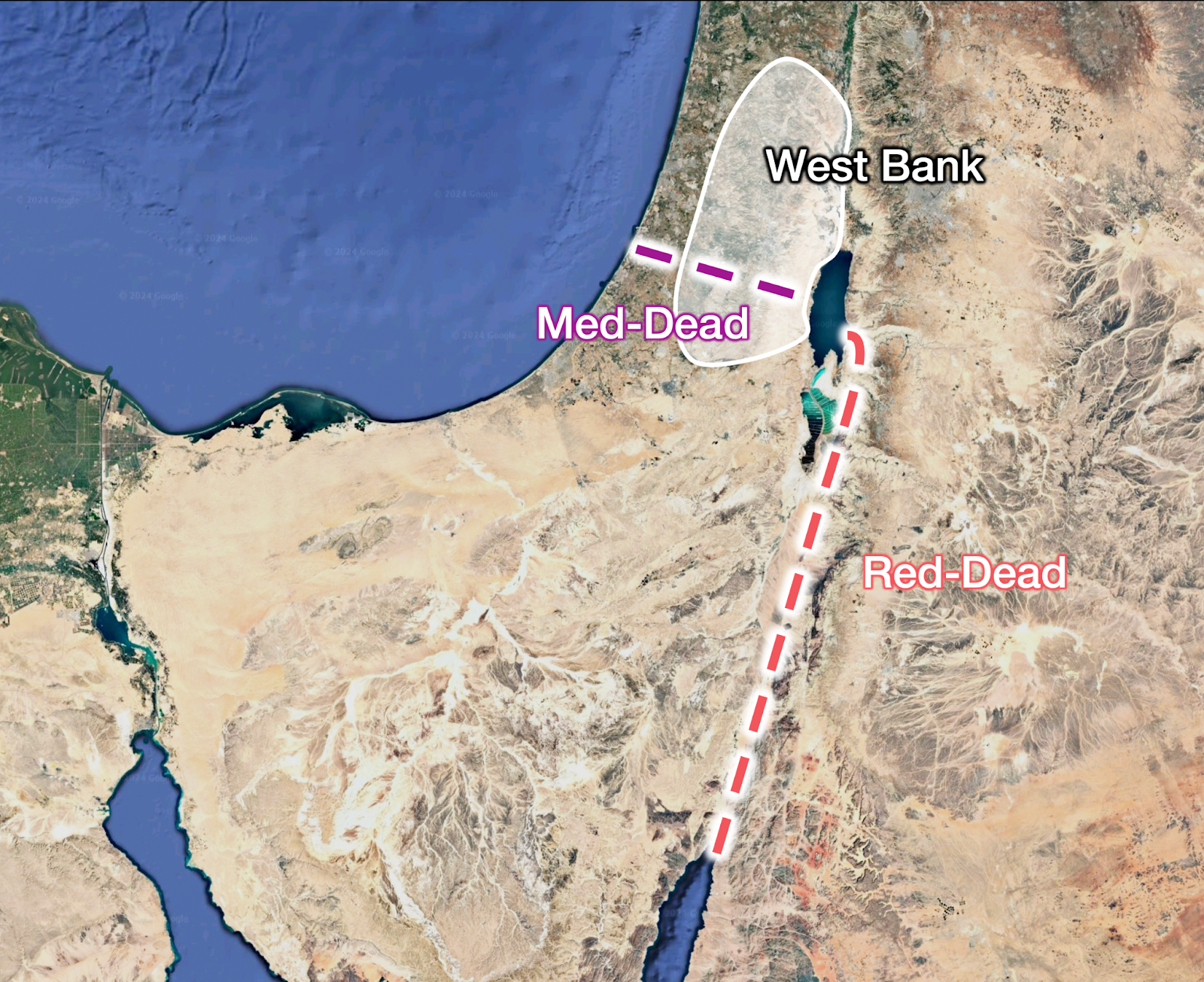
Why didn’t Israel cooperate? A number of reasons, including the high cost of the RSDSC and objections from environmentalists. Israel also had a cheaper, faster alternative Dead Sea project under consideration: Mediterranean-Dead Sea Canal (MDSC).
Alas, Israel has not pulled the trigger there, either, likely due in part to geopolitical instability — the MDSC would require construction in the West Bank. Israel’s water management priorities have also focused on drinking water.
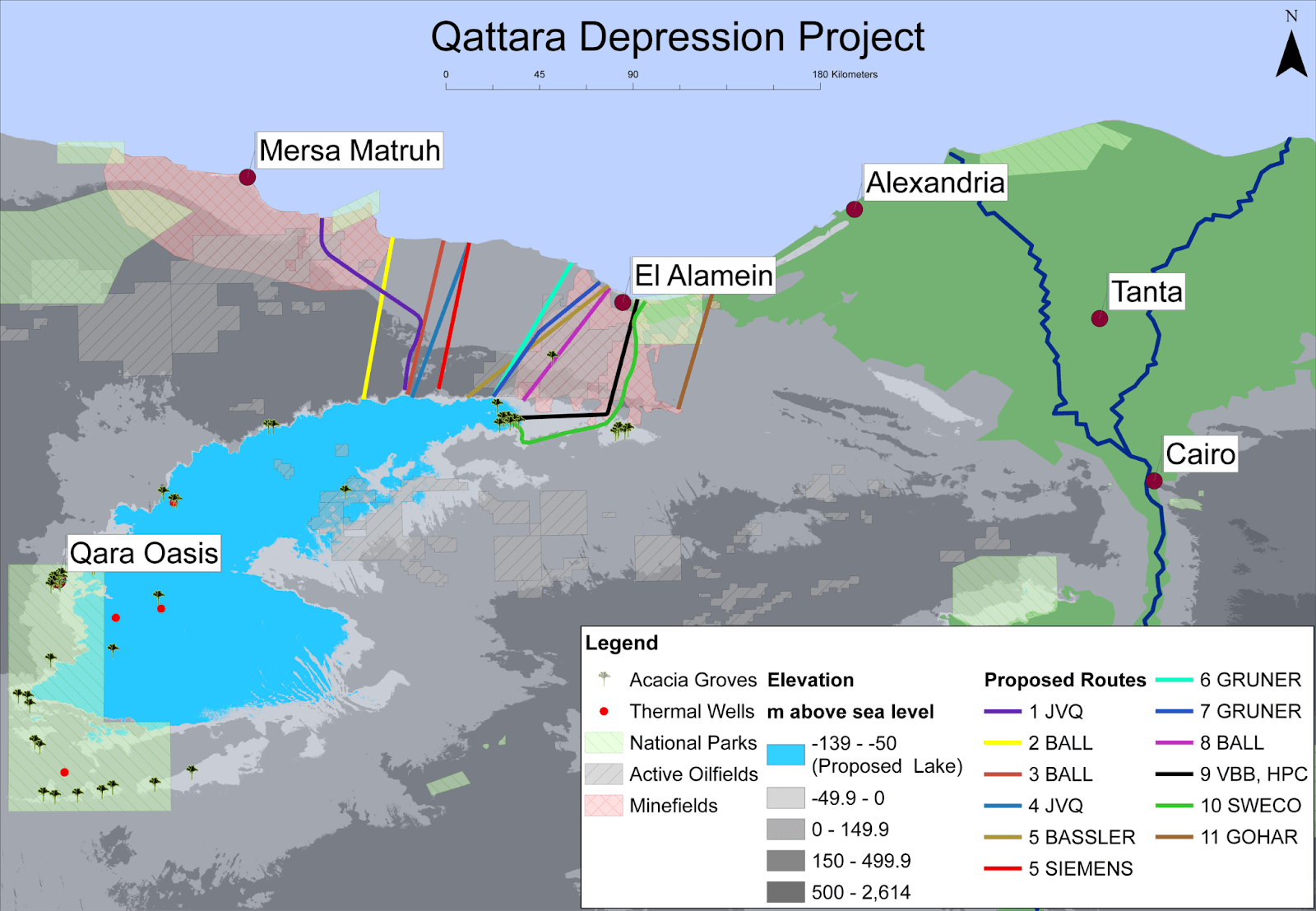
The Qattara Depression
Geopolitics may be too unstable for the MDSC right now, but there is a similar depression that doesn’t have that issue because it’s located entirely in one nation: Egypt.
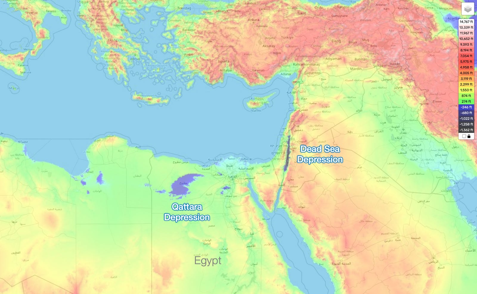
The Qattara Depression is 300 feet (91 meters) below sea level, and because it’s farther south than the Dead Sea and the Mediterranean, the region is warmer and drier.
It used to be home to shallow lakes and marshes, but it’s hypothesized that its access to the ocean closed off one day, like what happened to the Mediterranean. Hot, cut off from the ocean, and without enough rains and rivers feeding it, it dried up, leaving behind only sand and salts.
Where life used to thrive, now there’s just death and desolation — but what if we connected the Qattara Depression to the Mediterranean, flooding it with water?
Parts of the Qattara Depression are just 34 miles (55 kilometers) from the Mediterranean Sea, and we could build pipelines to cover the distance between the two. This flow of water could generate hydroelectricity, too, which could be used to desalinate some of the seawater into freshwater. The additional water and electricity could power new industries, residences, and tourism.
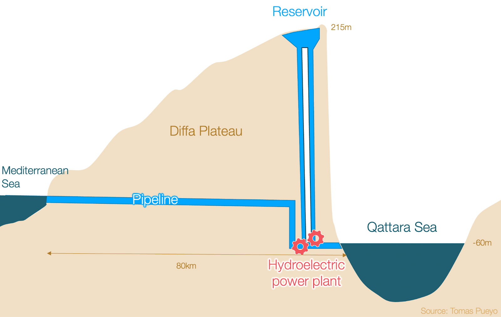
Evaporation from the newly formed Qattara Sea would increase local humidity levels, helping plants take hold and grow, which would reduce nearby erosion. It might also increase rainfall a bit east of the sea.
Creating the Qattara Sea would have a global benefit, too. Because the Depression would hold a lot of water — 290 mi3 (1,200 km3), or about 30% the volume of the Grand Canyon — filling it would reduce worldwide ocean levels by 3 millimeters, and its constant evaporation would slow the rise of ocean levels by up to 6%.
All these benefits come at low cost:
- The limited existing flora and fauna would be replaced by life adapted to the lake. However, there would be more life in general, including fish and birds that are nowhere in the region today.
- The local oases would be disrupted, but the new sea would dramatically increase the economic potential of the region.
- The freshwater table below the region would probably become brackish, but that water is barely used today anyway.
So, why hasn’t the Egyptian government flooded the Qattara Depression?
Financials. The mountains between the Mediterranean Sea and the Qattara Depression would need to be excavated — an engineering challenge so great that those who looked into it after WWII proposed using nuclear bombs to make the holes2 — and a study from 2012 estimated that this would cost nearly $2 billion.3
However, an undersea pipeline that brings water from Turkey to Northern Cyprus — traveling a similar distance (50 miles), and at an incline reaching 80 meters above sea level (the Qattara pipeline would travel down to 250 meters below it) — cost just $430 million.
That pipeline is only about one-third the size of the one needed for the Qattara Depression, but the order of magnitude is interesting. Also, have you heard of any recent innovation in tunneling costs?
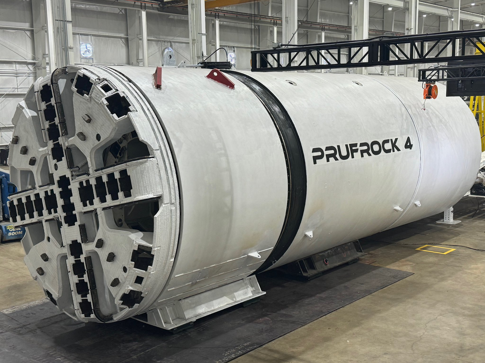
Elon Musk’s Boring Company says it is “targeting an all-in cost of a Loop Transportation tunnel of less than $8M/mile.” The distance needed to tunnel for the Qattara project would be 50 miles, meaning we could get a new sea for just $400 million.
In 2023, Egypt approved a new feasibility study for filling the Qattara Depression, but while we wait for the nation to decide whether or not to move forward with the project, let’s consider other places we could create new seas — including an outstanding location right in the U.S.
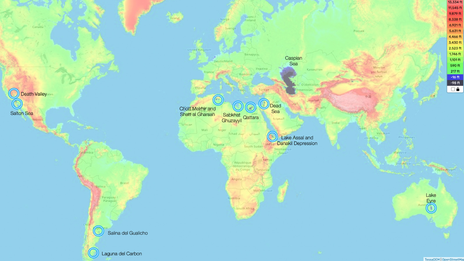
The Salton Sea
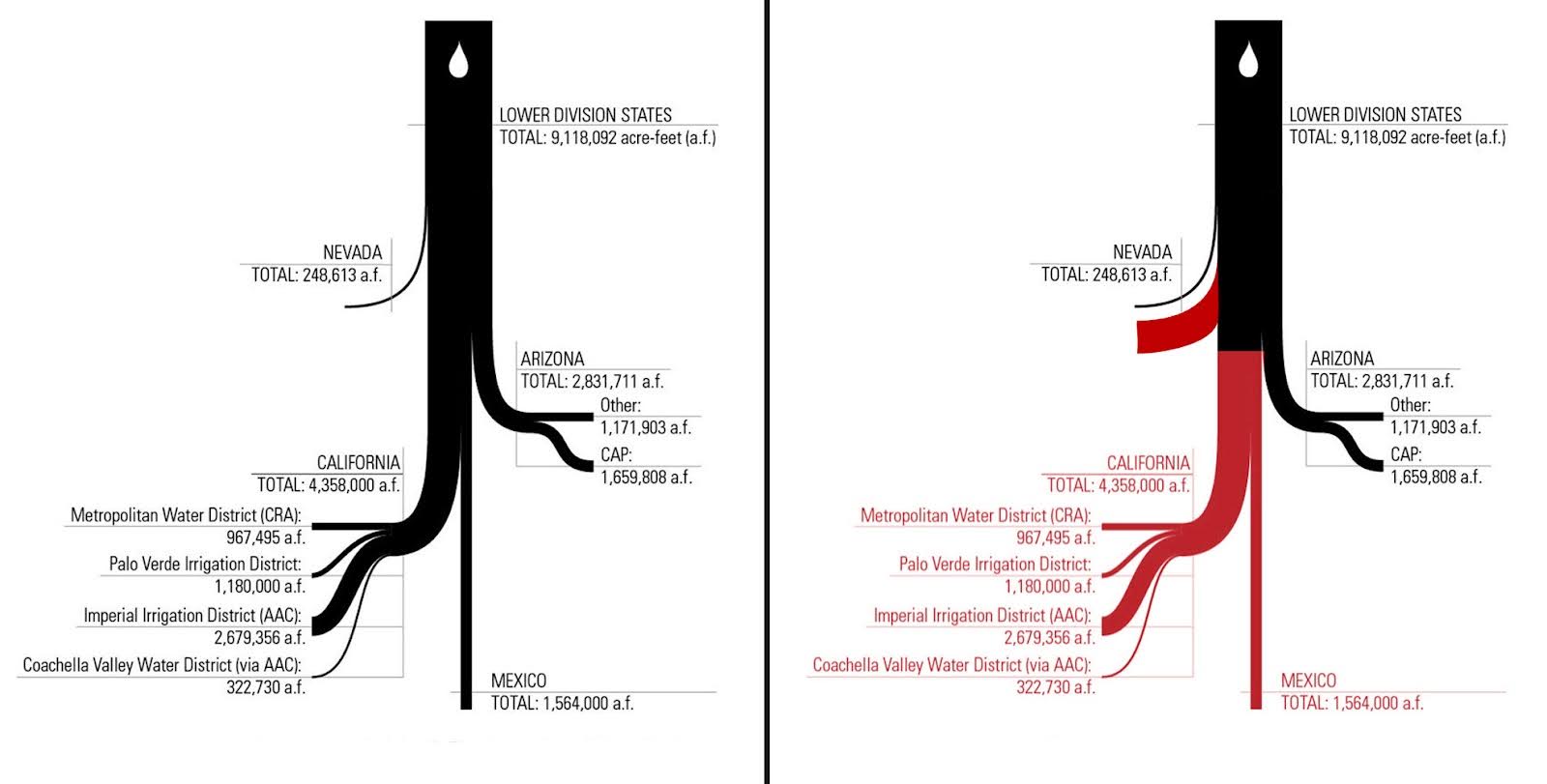
The Salton Sea is a massive below-sea-level depression located in Southern California between Palm Springs, Coachella, and the Imperial Valley.
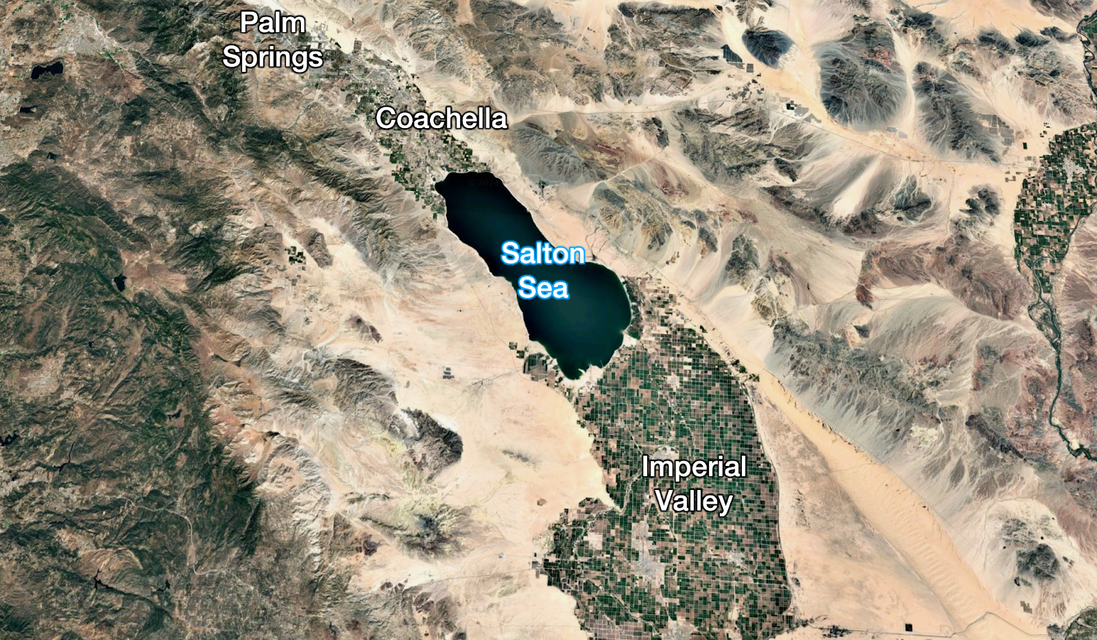
In the 1950s and ‘60s, it was a rich tourist spot, but today it is a dumpster. What happened?
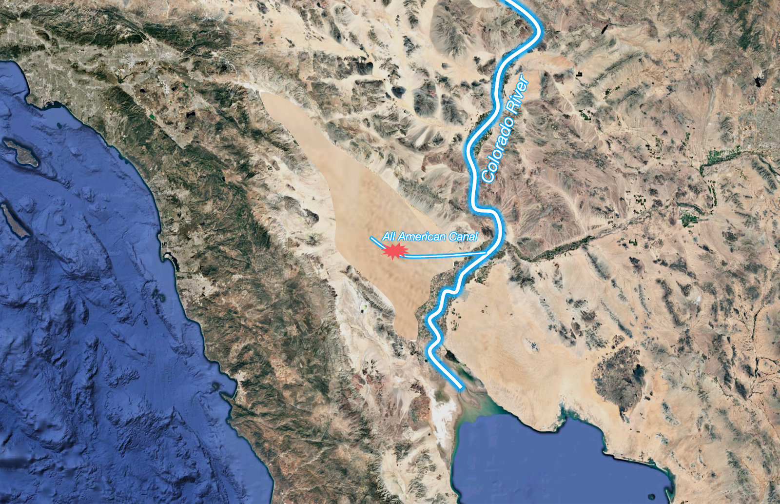
Throughout history, the Colorado River has alternated between reaching the Sea of Cortez and filling the Salton Sea. The last time the Salton Sea had dried up was around 1700, and it was still a desert in the early 1900s when an accident during the building of the All-American Canal diverted all the water from the Colorado River into the Salton Sink for two years.
For decades, this water made the Salton Sea a tourism destination. It also made the Imperial Valley one of the most productive agricultural areas in the world because farmers could flood their farms with the river’s sediment-rich waters. These, in turn, would flow into the Salton Sea, refilling it.
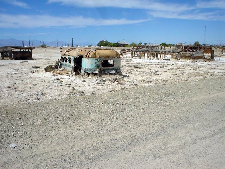
But as water became scarce in the American Southwest, the allocation to Imperial Valley farmers was reduced, overflow stopped, and the Salton Sea started drying up. Fish started dying off, birds stopped coming, and tourists abandoned the area. As the waters receded, the winds started blowing the sand of the exposed lakebed into the lungs of people in the area.
The Salton Sea is now the biggest man-made source of hazardous dust in the U.S., at levels 10 times higher than the acceptable standard. Los Angeles has spent more than $1.2 billion trying to suppress the dust, pouring 30 billion gallons of water onto the lakebed each year, but air-quality problems remain.
How do you solve this?
Make the Salton Sea great again
The Salton Sea is 230 feet below sea level, and it’s just 120 miles from the Sea of Cortez, with no mountains in between, so digging a simple canal would suffice to bring ocean water to the Salton Sea, reducing its salinity in the process.4 It would cost just $800 million and $40 million in annual maintenance. Adding a concrete lining would bring the costs to a bit over $2 billion.
For that cost, we would get several benefits:
- The Salton Sea tourism industry would return.
- Seawater contains plenty of lithium, which we need for batteries and other technologies. This lithium could be harvested from the sea.
- We’d revitalize the area’s real estate. This alone would create trillions in value.
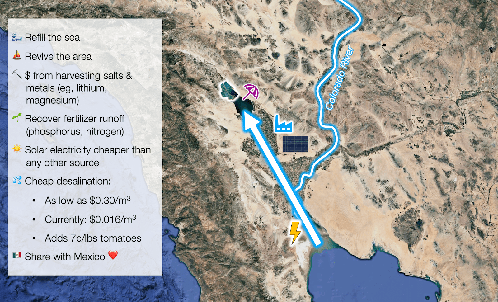
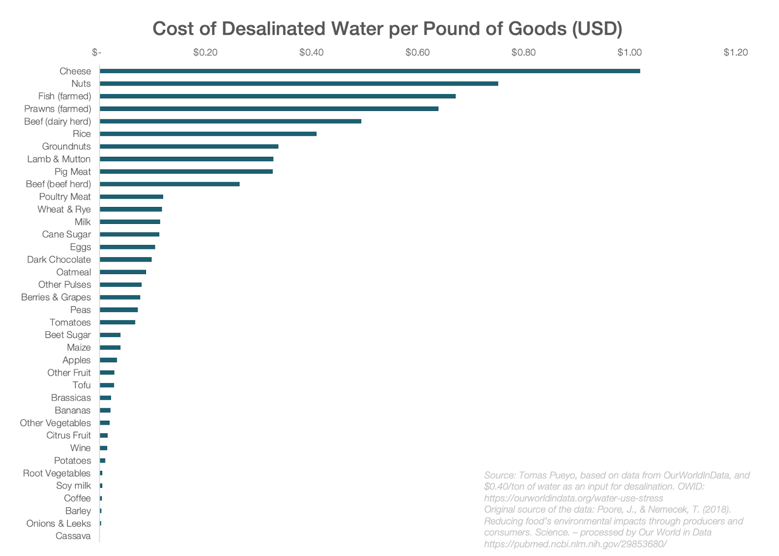
Additionally, the area has plenty of desert where we could put solar panels. We could then use the electricity to desalinate water for drinking and industrial use at $0.30/ton — that’s much cheaper than what that water costs in California today.
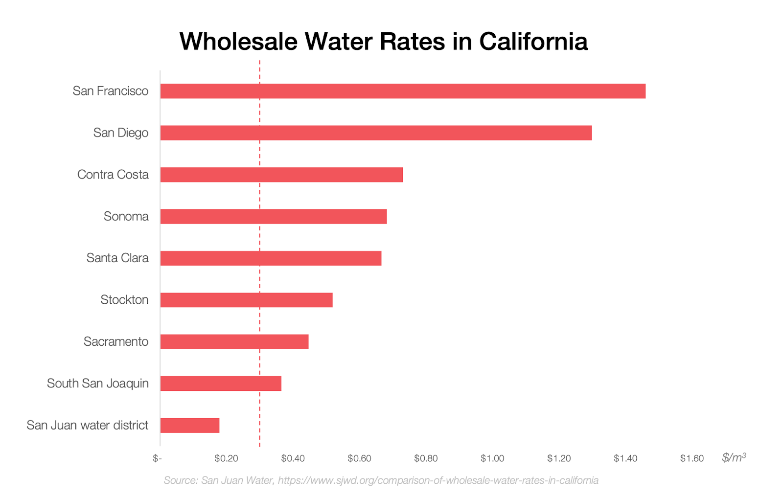
That desalinated water is more expensive than what agricultural water costs today — Imperial Valley farmers pay ~$0.015/ton — but it could still be used for some agricultural products. The difference would add just $0.07 per pound of tomatoes, for example.
Casey Handmer, the founder of Terraform Industries, has a similar plan, but he proposes refilling the Salton Sea with desalinated water instead of saltwater. The obvious drawback is that it would cost tens of billions of dollars. But there’s a little-known fact in favor: Somebody else is already refilling an inland sea with desalinated water.
The Sea of Galilee
Virtually all of Israel’s drinking water is desalinated. If you consider all uses (drinking, industrial, and agricultural), over half of its water is desalinated. The Israelis have achieved that by establishing six major desalination plants.
In periods of drought, though, Israel draws water from the Sea of Galilee to the north. Its water levels have been falling in recent years, so in 2022, Israel launched a project to begin refilling it with desalinated water. That refilling will begin in late 2025.
If Israel can afford it, California’s economy — which is eight times bigger — can, too.
More lakes in the U.S.
We wouldn’t have to stop at reviving the Salton Sea. We could create several new lakes in the U.S. — and each time you have a lake, you can build a new community.
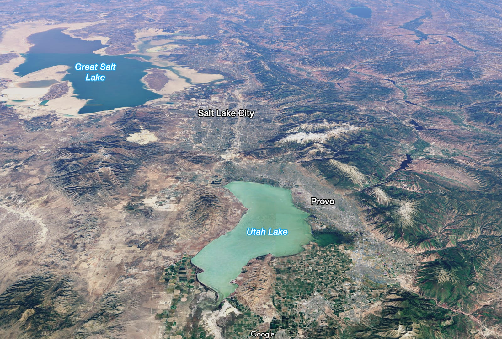
As its name illustrates, Salt Lake City exists because of the Great Salt Lake. Nearby Provo exists because of Utah Lake. Tahoe is an immensely valuable lake in the middle of the Californian Sierra Nevada. Las Vegas is an oasis in the middle of the desert that would not have been possible without Lake Mead, which was created by the Hoover Dam. Just south of that, Lake Havasu birthed Lake Havasu City, a community of 50,000 people.
A few existing lakes in the U.S. Sierra Nevada and Rockies could be revived to anchor new communities, but what if we created brand-new lakes? There were many more lakes in the U.S. just a few thousands of years ago that we could use as a basis for these.
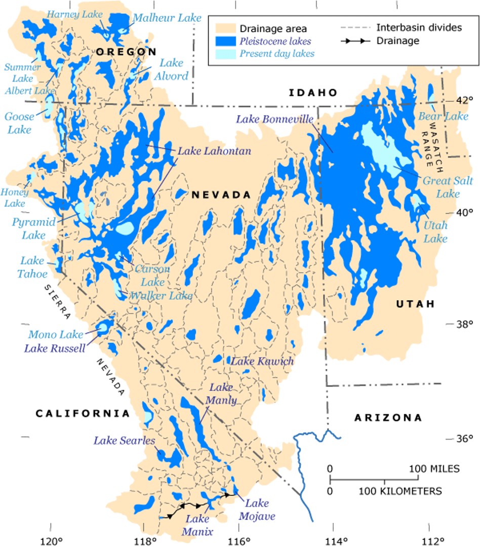
We could revive any of these lakes if we just sent enough water to them. But from where? Most of these places are more than 3,000 feet above sea level. Pumping water up to them from the ocean would be very expensive, so where else could we get the water from?
The Colorado River.
The vast majority of its waters go to low-lying areas of California and Mexico. But what if we desalinated seawater for these regions instead and kept the Colorado River’s freshwater in Nevada?
Then we would barely need to do any pumping. The only cost would be desalination, which at $0.30/ton should be quite affordable. All that water could be diverted into recreating the lakes that used to exist. And for every new lake, we could create a new community.
With its own rules.
With its own culture.
With its own urban design.
With its own priorities.
For centuries, humans saw nature as what it was to them: brutal, cruel, something to conquer to eliminate pain. But when we did, we overplayed our power, leading to the destruction of nature. Now, the pendulum has swayed in the opposite direction: We fear touching anything. Some even advocate for a world with fewer humans.
But that’s not the right lesson. Of course we should be thoughtful with megaprojects. We should weigh the pros and cons and try to mitigate the cons. But that shouldn’t freeze us into inaction.
We should be modifying the world. We should make it a better place. We should flood the Qattara Sea. We should refill the Salton Sea. We should create new lakes in the Rockies. We should engineer the Earth again to make it a better place for humans and wildlife.
- Russia could, however, refill it with water from the Black Sea, as today Russia is diverting so much water from the Caspian that its levels are going down fast.
- There were other potential concerns, such as coastal erosion or the risk of triggering unexploded mines from WWII, but these seem tiny compared to the excavation issue.
- “Integrated Wind and Solar Qattara Depression Project with Pumped Storage as Part of Desertec” Weisensee & Ragheb (2012)
- The Salton Sea’s salinity is 4.5-5%, so about 50% higher than the Pacific Ocean’s.
Tomas Pueyo is the author of Uncharted Territories, a newsletter helping readers understand deeply how the world works today to navigate the world of tomorrow. Subscribe to it here.