Strange Maps
A special series by Frank Jacobs.
Frank has been writing about strange maps since 2006, published a book on the subject in 2009 and joined Big Think in 2010. Readers send in new material daily, and he keeps bumping in to cartography that is delightfully obscure, amazingly beautiful, shockingly partisan, and more. "Each map tells a story, but the stories told by your standard atlas for school or reference are limited and literal: they show only the most practical side of the world, its geography and its political divisions. Strange Maps aims to collect and comment on maps that do everything but that - maps that show the world from a different angle."
featured


All Stories
Like Russia or the UK, Turkey is the successor state to a once dominant world power. And much as in those other countries, nostalgic memories of Empire (the Ottoman one, […]
n How little information do you need to be able to draw a map? This zen-like question provided the basis for a short article in the May 21st, 1971 issue of […]
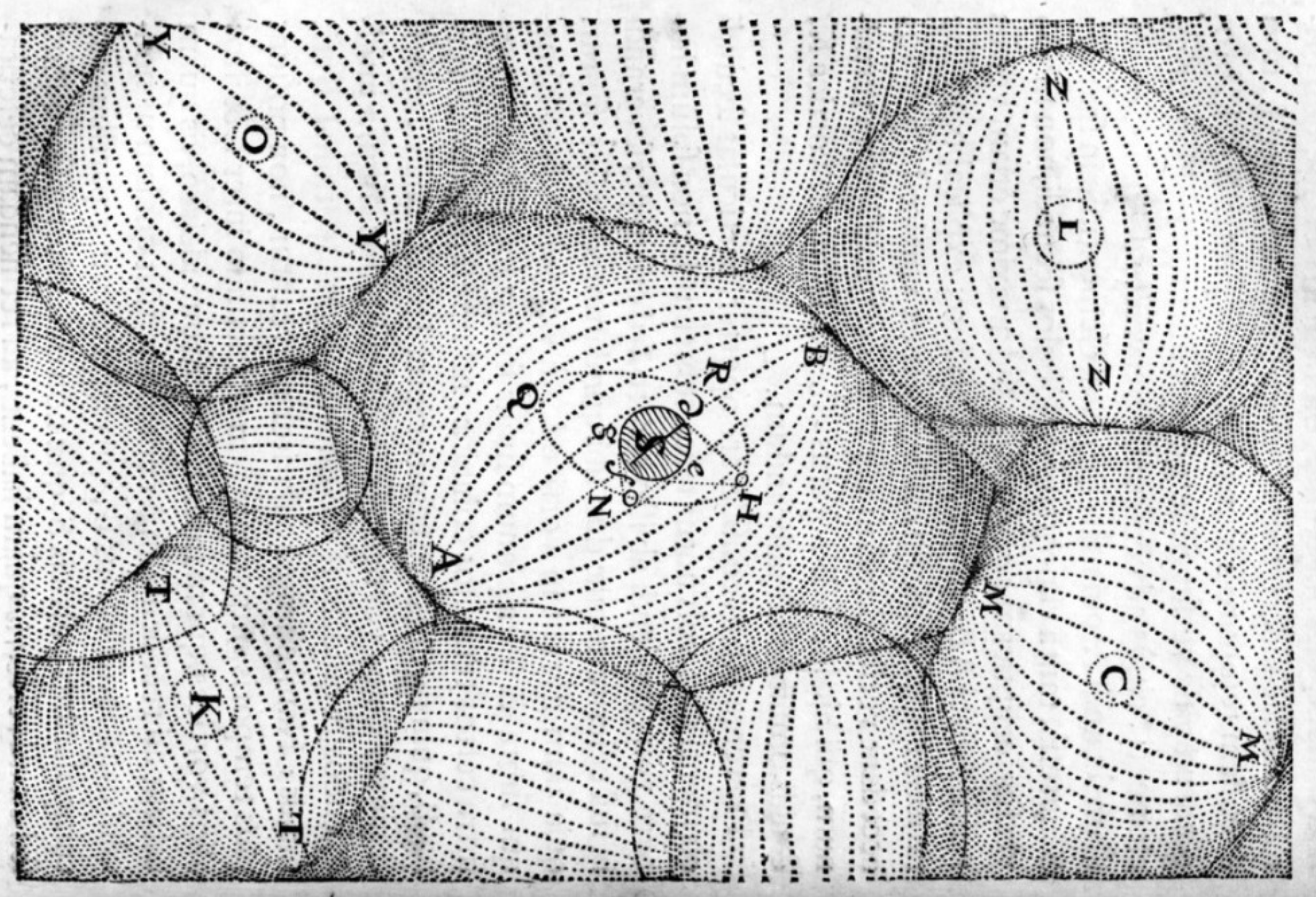
Faith and reason, usually jostling for primacy over one another, unite on this map to describe [t]he Earth-sphere after the Deluge in its broken state, shown with Mountains and valleys, […]
Designed by J.R.R. Tolkien’s son Christopher and included in most editions of the Lord of the Rings trilogy, the map of Middle-Earth is one of the best-known examples of fantasy […]

The weird sport of hunting for animals in maps

A strange return to the age of the dinosaurs


Yes, but are they christianised Turks, or turkified Bulgars?

The McFarthest place is somewhere in South Dakota

n Italy’s famously boot-like appearance might be what gave Emad Hajjaj the idea for this footwear-oriented world map. Hajjaj, a cartoonist for the Jordanian newspaper Al-Ghad, manages to craft all […]
This world map slices up the globe into two egg-shaped pieces and, for some reason, a kidney-shaped one. It purports to show the world’s three panregions (*), and the world […]
n In London Orbital, writer, walker and Londoner Iain Sinclair approaches his favourite subject – his home town – by circumambulating it. The book details his trek along the M25, […]
n As seemed to be the rule in those days, Shane MacGowan‘s stage appearance was over in minutes. After incomprehensibly muttering the lyrics to a new song, a couple of roadies […]
At last, the worlds of cartography, vexillology and population statistics meet! This map was inspired by earlier maps of the US, with its states renamed for countries with a similar GDP […]
If there were only 100 people in Ireland, 55 of them would be speaking only English, 39 of them would be speaking mainly English, and occasionally Irish, 2 of them […]
n Fixing her regional loyalty in indelible ink on skin, Julia had a map of Portland, ME tattooed on her shoulder. A comparison with the more conventional map on the […]
How long does it take to travel from London to elsewhere? The answer is provided by this map, showing a set of expanding circles centered on the British capital, each […]
The Bir Tawil Triangle is a desert of sand and rocks on the border between Egypt and the Sudan. It is also officially the most undesired territory in the world. […]
n How would you eliminate almost half the planet by subtracting just 5% from it? This map shows you how: delete the countries that constitute the bottom 5% of global […]
In geopolitical theory, the term ‘Heartland’ refers to the area between the Volga and Yangtze rivers, and between the Himalaya and the Arctic regions. According to H.J. Mackinder’s 1904 article […]
n Safe, neutral, boring Switzerland is a strangely fertile source of curious cartography. Previously, this blog has zoomed in on wartime contingency plans for a Schweizer réduit (#109), Jules Verne’s […]

If extraterrestrials were monitoring American television, here’s what they would be watching. In the Fomalhaut system, for example, maybe everybody’s crazy about Miami Vice.
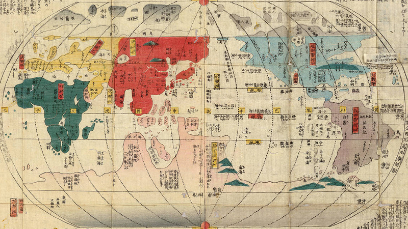
Centuries of isolation left the Japanese with limited knowledge of world geography


Some places exert a morbid attraction on the terminally disenchanted – like light pole 69 on the Golden Gate Bridge

An obscure but ancient branch of loom art, weaving current events into carpets
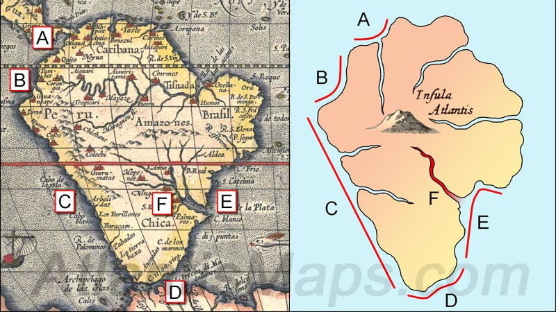
Plato’s fabled continent, as depicted by Kircher in the 17th century, looks a bit familiar…
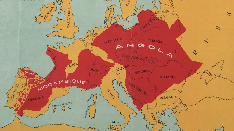
Portugal’s inferiority complex leads to a very curious comparison

America’s demographic centre of gravity has been moving steadily eastward for over 200 years