Mapped: How warm your city will be in the 2080s
- Climate change is so big and slow that it sometimes doesn’t seem real. But it’s still happening.
- This map gets real by being specific. It identifies the place with a climate that your city is estimated to have in 60 years’ time.
- For some cities, that may feel like an upgrade. Others, however, will have a climate literally out of this world.
The way we’re not dealing with climate change has changed. We’re no longer willfully denying the mounting danger. We’re cheerfully ignoring it.
As a telling example, consider a new type of summer story that has become a staple of Danish TV news. The topic: so-called “coolcations” — in short, the reversal of the traditional flow of European tourism. Instead of heading south for hot weather, more and more Europeans are traveling north, where it’s cooler.
The good news is only part of the picture
A reporter will point a microphone at a group of Italians enjoying the architecture of Aarhus or a Spanish family visiting the H.C. Andersen Museum in Odense. And? They’re loving it. Not just the cities, but also the weather. Especially the weather. “I like it, because it’s so changeable”, Monica Sirotti, visiting from Italy, told Danish broadcaster DR in mid-July. “I’m so tired of it just being hot.”
The tone of the piece is light-hearted, even self-congratulatory: See how well Denmark is doing out of climate change! But zoom out to the whole of Europe, and that good news is only part of the picture.
Since 1991, summers across Europe have been getting warmer by about 0.5°C (1°F) per decade, with starkly different outcomes in the north and south of the continent.

In Denmark, as in much of northern Europe, temperatures in July and August now generally hover between 20 and 25°C (68-77°F). Do bring an umbrella: long stretches of sunshine are still punctured by refreshing rains.
That’s pleasant compared to Mediterranean Europe, where the summer months are increasingly dry and unbearably hot, with temperatures regularly surpassing 40°C (104°F) and devastating wildfires a constant threat.
For now, the Danes and other northern Europeans are benefiting from sunnier summers (and a slow increase in “coolcations”). But climate change is not stopping. How hot will the summers of the future get?
Your future climate is already here
This interactive map, created at the University of Maryland Center for Environmental Science, will tell you. It uses a statistical technique called climate analog mapping, the central assumption of which is that your location’s future climate is already here, except that it’s somewhere else.
Looking 60 years into the future, this map tool predicts the climate of thousands of cities, towns, and suburbs in the 2080s by finding their climate analogs today. You can choose between two emission scenarios, also known as Shared Socioeconomic Pathways (SSPs), as identified by the Intergovernmental Panel on Climate Change (IPCC).
The high-emission scenario is SSP5-8.5, also known as the “business as usual” scenario. This is a fossil-fuel-based future in which CO2 emissions triple by 2075. From 2080, this would lead to an increase of the global average temperature by 4.4°C (8°F).
The reduced-emission scenario is SSP1-2.6. That’s a much more sustainable path, implying that we manage to cut CO2 emissions to net zero by 2075. In that scenario, the planet will warm by only about 1.8°C (3.2°F). For each scenario, the map generates five potential outcomes, as well as an average.
Is climate analog mapping a good way to shock people into climate action? Perhaps not. If you live in Denmark or other places far enough north, even the worst-case scenario sounds like an improvement. It’s only farther south that things get scary — and deadly.
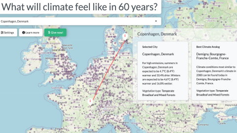
Let’s start with the Danish capital. The most extreme forecast of the five high-emission outcomes puts Copenhagen’s climate in the 2080s on a par with today’s climate in Vernet-les-Bains, so far south in France that it’s almost in Spain. That would mean about 2,600 hours of sunshine per year, and very little rain.
The average of the five high-emission forecasts says Copenhagen’s summers 60 years from now will be 4.7°C (8.4°F) warmer and 10.4% drier than they are now, and its winters 4.6°C (8.4°F) warmer and 16.8% wetter. That corresponds to today’s climate of Demigny, a village in the Bourgogne region of France, about 500 km (310 miles) further northeast from Vernet-les-Bains.
Bourgogne, as in Burgundy, right? If turning Denmark into a Nordic Napa Valley is the worst-case scenario, then what’s a better one? As the map shows, the more sustainable route would make Copenhagen’s summers just 1.6°C (3°F) warmer and 0.7% wetter. That’s similar to today’s Raddestorf in Lower Saxony, a region in northern Germany not known for its fine red wines. To be honest, most Danes would probably prefer the worst-case future.
A hotter, wetter New York City
But what about those destinations farther south? In the high-emission scenario, 2080s Madrid will have the current climate of Pedro Abad, a place just 275 km (171 mi) south of the Spanish capital. That may not seem like a lot, but it corresponds to summers 7.8°C (14.1°F) hotter and 11.1% drier.
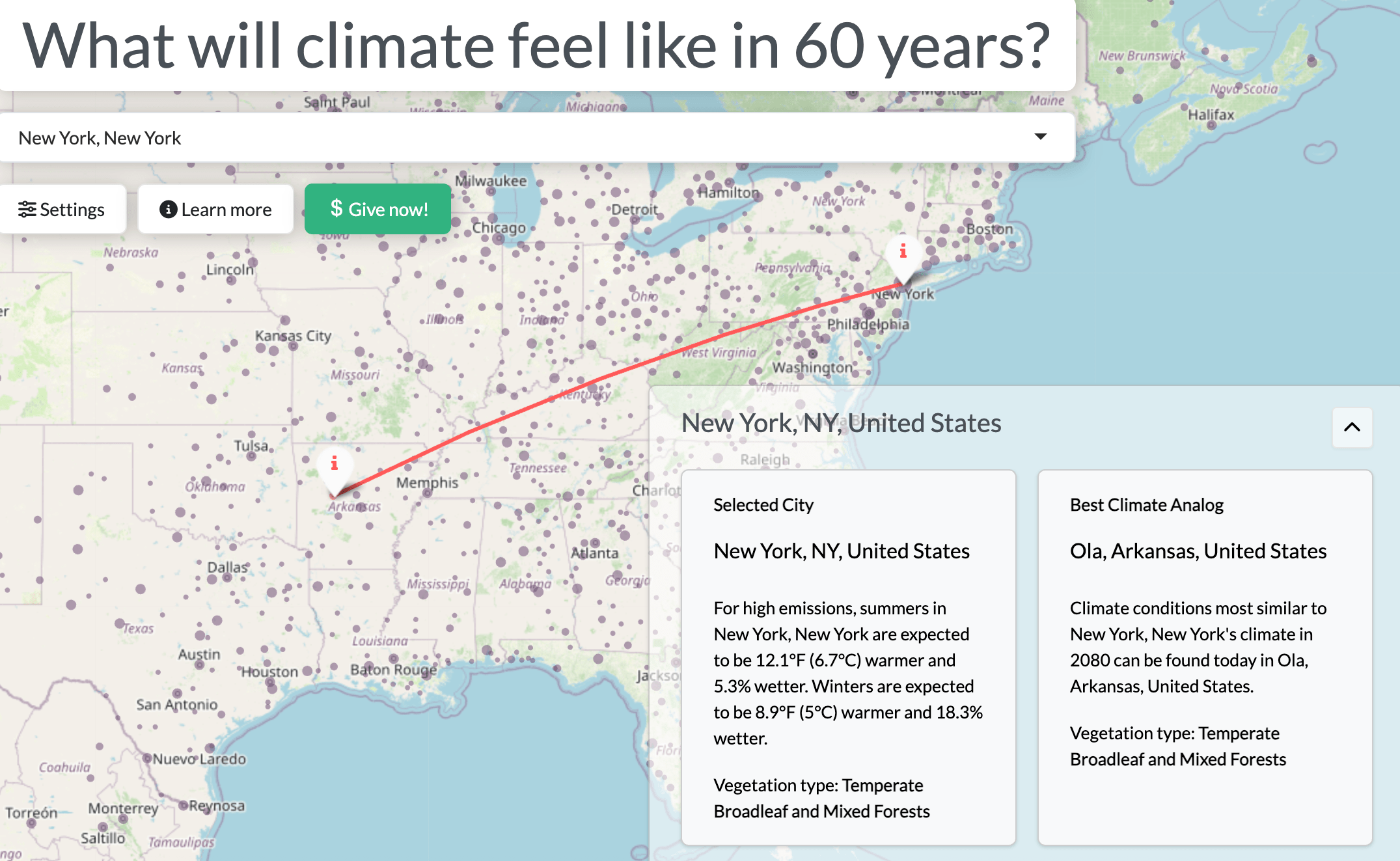
When does hotter start to sound like less fun? Perhaps when it’s also wetter. New York City’s worst-case scenario predicts an even muggier climate in the future, one similar to that of today’s Oil City in northwestern Louisiana, 1,200 miles (1,950 km) to the southwest. The average of the five high-emission projections is in eastern Arkansas: the town of Ola, 12.1°F (6.7°C) hotter and 5.3% wetter in summer than New York today. Ola’s winters (and perhaps those in New York’s future) are also hotter (by 8.9°F, or 5°C) and wetter (by 18.3%).
The map app generates several unlikely climate twins:
- In the 2080s, New Orleans could have the climate of Banqiao, in Taiwan.
- Ottawa could feel like Piedmont, in southern Missouri.
- Miami would have the hotter, drier summers and hotter, wetter winters of Abu ‘Arish, a town in Saudi Arabia on the border with Yemen.
- Not all future climates are half a world away. Los Angeles in the 2080s would feel like Rialto in the San Bernardino Valley, just 50 miles (80 km) east of downtown LA.
But stray too far south, and an ominous message replaces the forecasts. When we try to find the 2080s climate for Riyadh, the capital of Saudi Arabia, this pops up:
Future climate for this location is expected to be unlike anything currently found anywhere on Earth, so there are no climate matches for this location.
The “intermediate” scenario is still deadly
Clearly, climate analog mapping has its limits, as it cannot produce a forecast that goes beyond the most extreme climate on earth today.
How likely is that worst-case scenario? Based on current emissions levels and international commitments, we’re tracking roughly between SSP2-4.5 (intermediate emissions) and SSP3-7.0 (high emissions), with the lower end of that spectrum likelier. That could mean the global average temperature would rise by up to 3.5°C (6.3°F) by 2100.
While not as bad as the worst-case scenario proposed by this map tool, it would still be enough to make the world in 2100 a far worse place than it is today.
In this “intermediate” scenario, deadly heatwaves will become routine in large parts of Africa, the Middle East, and South Asia. Sea-level rise will swallow low-lying islands and coastal regions, displacing millions. Ecosystems in the ocean and the Amazon will likely collapse, and crop yields will plummet, putting hundreds of millions of people at risk of starvation.
These hungry and displaced people will become the climate refugees looking to migrate to areas where the climate is still bearable. The direction of those travels will be the same, but we probably won’t call them “coolcations” anymore.
Strange Maps #1277
Here’s some more background on the map tool and the future it seeks to determine.
Got a strange map? Let me know at strangemaps@gmail.com.
Follow Strange Maps on X and Facebook.